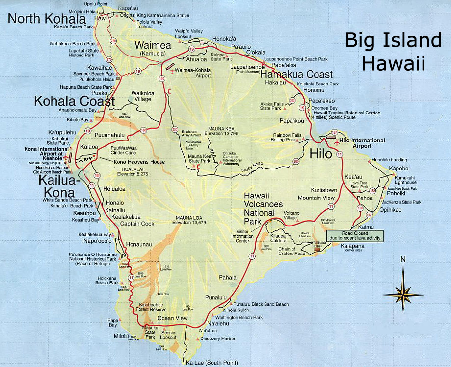
Tuesday, December 25, 2012

Catalina Island - Relaxing and Beautiful getaway

Link to pictures: Catalina Island
We visited Catalina island on Thanksgiving weekend in November when it was great spring-like weather. Catalina Island is close to Los Angeles. Nearest airport woulf be either LA or Long Beach. We drove to Long Beach from Sacramento and stayed in Long Beach for a night. From Long Beach, it is a one-hour ferry ride to Catalina. Long Beach is as a great small city. We stayed at Hyatt Regency, which was close to the pier. Hyatt had excellent dinner and great breakfast buffet. Shavi got to run early morning on the bike trail at the pier, which he said was awesome. We parked our car next day in the parking lot of Catalina Express which was very convenient. We had reserved our ferry tickets a week in advance. Even then we had been unable to get the time slot that we wanted. Reserving seats much in advance is a good suggestion. Catalina Express starts from three stations: San Pedro, Long Beach and Dana Point. Catalina Express is a bit pricey but then there is no other option unless you want to fly there but of course, that is not cheap by any means!

Catalina Express is a great ferry ride. People are usually there early (at least 45 mins before the ferry time) to get good seats. The ferry has an open upper deck but it gets filled fast.
Catalina has a small town of Avalon which is the primary tourist destination and the quaint village of Two Harbors. The ferry service to Two Harbors is only offered from San Pedro. We reached Avalon. The hotels in Avalon generally have shuttle service from the Catalina harbor to the hotels. We decided to just walk since it was not much distance. There are not many cars on the island. With a 13- year waiting period for getting cars to the island, people prefer to drive around in golf carts. Golf carts and bikes are easily available for rent for local sight-seeing.

We spent our first evening on the island, strolling on the streets. It has a small strip with various restaurants and bars. Great way to spend an evening at the strip with the pier facing it. Beautiful views.
For the next day, we decided to rent bikes and ride on the Trans-Catalina trails. The bike passes for the trails are to be purchased from Catalina Island Conservancy, whose office can be easy located in Avalon. Everything can be easily accessed on foot. Again, the bike passes are expensive since they are valid for one year. At the time, we went, it was $65 for two, not including bike rentals. We rented bikes from Brown Bikes, which was great but bikes are to returned before it gets dark. Going for hiking on the trails does not require any official pass but it is donation-based and the Conservancy office gives you a pass for the trails. The trail is around 26 miles one way.

We started on our bikes and decided to go 5-6 miles one way, to reach the ‘Airport in the Sky’. The first 3-miles of the trails were brutal since they had 10% gradient. Pedaling on the bike was hard and I almost walked those 3-miles with my bike but on the way back, it was fun. I came back flying!
There are not many rest stations on the trail. The closest one is a small park, around 3.5 miles from the start. So, it is advisable to carry lots of water, especially since the trail is mostly uphill. We reached Airport on the Sky, which is a small local airport at 1602 ft. elevation. We did not see many people on the trail except for few tour buses. The airport has a nice eating place and good restrooms. The food at the one and the only one restaurant at the airport was good. Going further up on the trails towards the other small town on the island: Two Harbors, would have required lot of time and energy since it has 10-15% gradient and then of course a place to stay at Two Harbors. So, we decided to return back to Avalon before it got dark.

People who want to go to Two Harbors, generally reserve a hotel in Two Harbors for the night. Camping is another option.

Avalon is a small town with good cell coverage and wi-fi. It is a great relaxing way to spend weekend. We spent almost 3 days there and felt they were just sufficient. The island also has several other activities like snorkeling, scuba diving, zip-lining, tubing, fishing, paddle-boarding.

Link to pictures: Catalina Island

Thursday, October 18, 2012

Desolation Wilderness (El Dorado forests), near Tahoe

Pictures of Desolation Wilderness.

True to it's name, Desolation Wilderness area is one of the best place for hiking. It's a true wilderness experience, with pristine lakes and spectacular mountains scenery. You can approach the trails through the south, north, east or west side.

For our very first time in the area, we chose the trail from Echo Lakes to Lake Aloha.


From US 50 highway, if coming from Sacramento, turn left onto Echo Summit Rd/Johnson Pass Rd and then turn left onto Echo Lakes Rd/Forest Route 11N05/Porcuine Rd. Continue to follow Echo Lakes Rd and you will shortly see a parking lot on your left. It is the Echo Chalet. (You can look for directions to Echo Chalet on google maps).
Parking is sufficient and is free. This area is under the El Dorado National Forests Services and has several trails and some campgrounds. For camping, permits are required but not for day users. Day users just need to sign in or get a permit from the self-kiosk at the beginning of the trail. There is a small store and some toilets at the beginning of the trail. Toilets are not clean at all, so be prepared ahead of time.

It is around 12-miles round trip with not many people on the trail, which makes it even better. Most people backpack there. There is 2 miles of uphill one way, while going up towards Lake Aloha and the terrain is quite rocky.


There are several short trails on the sides, on the trail, that you can take to increase your hiking mileage. For people who want to cut the main trail short by 3 miles each way, there are water taxis available after 2-3 miles of going up. The water taxis are not open all the time, so check before hand.

We went in September end and needed a jacket, even when it was sunny. Totally worth it and now I have to look for the next trail at Desolation Wilderness for our next hike.

The Great Reno Hot Air Balloon Festival

Pictures of the event: Hot Air Balloon show.

The pictures of the balloons say it all. Reno Balloon festival, which is held every year in the 1st or 2nd week of September is one of the very best things that I have seen. The event is held at Rancho San Rafael Regional Park. Huge lighted balloons dancing in the sky at night and then in the morning, is absolutely fabulous. It is a feast to the eyes.
We went there in Sep 2012. Stayed in a hotel at Reno overnight to catch the show early morning, when it is still the dark at 5am on Saturday. The same show is presented both Saturday and Sunday, though it might change every year. The information is easily available on their website. We stayed at El Dorado Casino and hotel. It was a decent hotel and good to stay for a night.


There is a shuttle service to the event area in the morning which leaves around the downtown area, which was 7-8 mins walk from our hotel. No one really had the correct information about the bus service but we figured it out. The first bus leaves at 4am and the second one at 4:30am (not sure if there are 2 or more). We took the 4am bus so that we could be in the park on time and have a place secured for ourselves and our lawn chairs. Thankfully, the bus was not over-crowded since it was too early for some people. I would recommend taking the shuttle and not taking the car to the park for parking since parking is very limited.

Carrying lawn chairs or something to sit on and a blanket, is a good idea. Yes blanket, since it gets very cold out there. You can keep going as far as you can inside the park, to catch a closer view of the balloons. It's easy to figure out. There are a lot of food stalls including coffee stalls and porta pottys inside the park, close to where the event takes place. The lines are really long as the event is attended by lot many people than you would imagine.


As I mentioned before, it gets pretty cold in the park, even in September. We thought it was an insane idea to carry anything warm with us, but it was an excellent idea to carry jacket, gloves and a cap. We needed them all and still felt cold, as the early morning kept progressing, until the sun fully showed up.

The main events generally end around 11am - noon. It was a spectacular event. Plenty of great photo opportunities. I am pretty sure I would want to go there every year!


For more pictures, please click here: Hot Air Balloon show

Sunday, September 2, 2012

Bodega Bay and Fort Ross - Labor day weekend trip

Bodega Bay was a quiet and peaceful trip. The aim of this trip was to enjoy some peace and that is exactly what we did by staying in Fort Ross. There was no cell phone signal in the place where we spent the night - Fort Ross Lodge. It is located 12 miles north of the small town of Jenner (around 20 mins), 2 miles north of Fort Ross State Historic Park. The lodge is directly across the street from Fort Ross store. The lodge has a hot water bath tub for those who want to use it. They provide BBQ areas as well.

Fort Ross State Historic Park is a little park, good for kids probably.

We visited the Armstrong Redwoods State Natural Reserve (17000 Armstrong Woods Rod, Guerneville, CA 95446) which is less tham 20 miles from the lodge. Nice easy trails upto 3 miles, a strenous 5.6-mile trail and a strenous 9-mile trail.

We missed going to Salt Point State Park which has a beautiful beach and some good trails. We instead went to a hidden public overlook area where there were very few people. There was a steep trail of around 0.7 mi to get to the overlook but totally worth the views.

Friday, July 20, 2012

The Gorgeous Island of Hawaii: The Big Island

Link to the Album:Big Island

One of our best vacations was our trip to the Big Island, Hawaii in the first week of July 2012. We tried to cover almost the entire periphery of the island, making full use of the 4.5 days we had there. We landed in Hilo (ITO airport- east side of the Island) and flew back from the same airport. We chose Big Island over other islands in Hawaii, since it is not too touristy and not commercialized, has active volcano sites and has the true feel of a beautiful, lovely island with rain forests, volcanoes, lava, beaches, waterfalls, valleys and great weather with rain and sun inter-changing roles within minutes. Big Island truly lived up to our expectations. Here is what we did and some travel tips:

Day 1: Landed Hilo around 2:30pm. Small and nice airport, so it was quick getting out. We rented the car from Budget Rentals. We had a bad experience with them since we had to change the car 2 times. We always go with Enterprise and always have had a good experience with them.
After picking the car and buying some food items from the nearby shopping complex which has a few major stores like Walmart, Walgreens etc., we drove to the nearby LILIUOKALANI GARDENS. These are beautiful Japanese-style gardens. It is a great place for picnic, especially for kids. Half-an-hour is good for strolling in the park.

We then proceeded to our hotel in Volcano which is towards south of Hilo and is very close to the Hawaii Volcanoes National Park. We stayed at VOLCANO FOREST INN. It was a great inn with very nice hosts. Would highly recommend that inn. Nice patio and nice view of the rain forests around. The inn is near to the Volcano Post Office. TIP: Keep an eye on the inn’s signboard at the entrance. The entrance is a short dirt road, leading to the peaceful inn. It is very easy to miss the signboard, especially if you are going there for the first time at night. We had food from the nearby Thai restaurant: THAI THAI RESTAURANT. The food was just ok, not fresh by any means but then there are not many places to eat in that little town. So, was glad with what we got!

Then we went to HAWAII VOLCANOES NATIONAL PARK to check out the glow from the volcano at night from the outside viewing area of JAGGER MUSEUM in the park.
It was stunning – a view I have never seen before! The full moon night made it even better, even though it was partly cloudy. The museum is open until 7pm but the park is open all night. There are a lot of people to catch the night views. So, go as late as possible. TIP: It generally gets cold there due to high winds. So, take a jacket or something. Both nights we were there, it was cold there even when in the July summer weather. TIP: Get there a little before sunset to get the before and after sunset views and to get a front place in the viewing area.

Click here for ROUTE MAP FOR DAY 1

Day 2: After the nice, light breakfast by the hosts of the inn, we went to see the July 4 parade in the town of Volcano which starts at the Post Office. It was fun. Seemed like all the people in the town were in the parade!

Then we went to Volcanoes National Park ($10 entry per vehicle, valid for 7 days). When we had gone last night, there was no one to collect money since we had entered the park after 7pm. We started with the Information center and then went for the THURSTON LAVA TUBE which is an easy trail and highly recommended by me. TIP: Get in there before the tourist buses get there. We got there around 10:30am and just after we came out of the tube, we saw several buses. It’s no fun in the tube with people.
Next we continued on to the KILAUEA IKI 4-mile loop trail in the park, near to the tube. It is listed as moderate to challenging. We did not find it challenging though, depends on why you call it challenging, must have been for the uphills on the trail, no shade for major part of the trail and an uneven surface. It was almost a two hour hike for us. Views of rain forests, the huge crater and walking through the crater was awesome. We stopped on most of the overlooks that were on the way while driving in the park.

Around 2pm, we decided to go to the Southernmost Point of the US: KA LAE. It is around mile marker 70, around an hour or more drive from the park. On the way, we stopped at the famous PUNALU’s BAKE SHOP. You cannot miss it. It is on the right side as you enter the town of Na`alehu. Good place to eat and their baked goods were awesome. Just past mile marker 70, you will see a signboard for Ka Lae and you turn right (if driving from Hilo). It’s an easy drive up to there. Nice and peaceful with very few people diving into the ocean. We spend around 30-40 minutes there and then headed to the GREEN BEACH.

There is a signboard which would guide you to the Green Beach area (Mahana Bay/Papakolea). You would see lot of cars parked in the parking area. People generally hire the locals for going to the beach. Hiking the almost 3-mile trail one way is not easy. It is a sandy/muddy uneven terrain and the trails are confusing with no shade at all. We had a 4 x 4 and so we drove up to there. TIP: Advise from a local: While driving, drive on the uppermost trail that you see. There are various trails formed on the ground but the higher ones are safer else there is a danger of getting stuck. It was a nerve-wrecking drive for me in the passenger seat! The green beach is beautiful. It was peaceful with not many people and beautiful views. There were locals on their 4x4’s asking people if they wanted a ride back for $10-15 one way. I would advise going with them both ways if you do not have a 4 x4. It took us around 20-25 minutes on our jeep each way to drive to the beach. It is worth mentioning here that the rental companies do not hold responsibility if anything breaks in the rental while going to Green Beach or Waipio Valley (on the north side of the island - details later in the blog) as they are both considered dangerous drives. Also, the residents offering rides for a fee are operating illegally as Hawaiian Homelands stopped years ago giving out permits for people to drive that road. TIP: As per forums, if you are going to park in the general parking area for a ride or hike, then do not leave any valuables in the car. Even though we are both avid runners, I am so glad we decided against that hike.

Now, we were ready to drive back to Volcano. On the way back, we stopped at PUNALU BLACK SAND BEACH. We did not spend much time there since there were a lot of people out there. Clicked a few pictures and then drove back to the Volcanoes National Park. We did the easy 1-mile one way DEVASTATION TRAIL there. Nice views. Then we drove up to the Jagger Museum to once again capture the night views of the volcano. It was a beautiful glow. What better way to celebrate July 4 by looking at those natural fireworks!

Then we drove back towards our inn to catch dinner at the nearby restaurants. The little strip is all that is in the town of Volcano. This time we went to the KIAWE KITCHEN. It is well known for its thin-crust pizza.

Click here for ROUTE MAP FOR DAY 2

Day 3: Went to Volcanoes National Park again to drive through the CRATER RIM DRIVE. It is a paved 23-mile road. This was when our 4 x 4 had some electrical problem and wouldn’t start. Good thing, we were inside the park on the crater rim road and so we hiked around 2-3 miles, viewing the craters and walking on lava, while we were waiting for the rental company to replace our car. It was a fun walk. We drove to the end of the road in our new car to see the HOLEI SEA ARCH. Awesome views and overlooks on the drive. Be sure to make a stop at all overlooks. They are all worth it. We missed the Pu'u Loa Petroglyphs trail since we had recently seen a lot of Petroglyphs in our last month's trip to Utah.

By 2pm, we were out of the park to drive towards Kona. We stopped for lunch in Na`alehu at HANA HOU RESTAURANT since it is the southernmost restaurant (until some other restaurant pops up south of it!). I would not recommend it. The food was not good and there were flies/bugs around. Not a very clean place to eat.

Next we drove to PUUHONUA O HONAUNAU NATIONAL HISTORICAL PARK on the way to Kona, almost 10-15 miles before Kona. Spent around an hour or so there, relaxing near the waterfront and watching turtles. Nice, relaxing place and at the same it tells you about the native Hawaiian culture. There are picnic tables near the waterfront in the park. Then we drove to Kona. Our resort, the Keauhou Beach Resort, had great ocean views. It’s a nice place – not too modernized but the great views made up for everything. So, we decided to relax there in the evening. They had good complimentary breakfast in the morning. Careful of the birds there. They love to peck in your plate if you are eating on the patio.

Most restaurants on the famous Alii drive close by 9pm but we found a few open for dinner until late also. We went to Rosa's Cantina and Sunset Grill. They had live music and great ocean views, with full bar. Not a bad place for my birthday drinks!

Click here for ROUTE MAP FOR DAY 3

Day 4: Checked-out from the resort to drive towards Hilo from the north side of the island. We first stopped at KALOKO-HONOKOHAU NATIONAL HISTORICAL PARK. We did not hike the trails there since it was too hot for me by that time. Nothing much there - we could have skipped it but it was on the way. It hardly took us any time there.

Our next stop was Hapuna Beach State Recreational Area. Beautiful beach with lot of people. There is no parking fee, so it is advisable not to keep costly stuff in car.
Next we went to PUUKOHOLA HEIAU NATIONAL HISTORIC SITE and went on the short trail there to see the Heiau (religious place of worship) built by King Kamehameha. Tourists are not allowed inside but it was a nice, short walk up to there. They also show informative videos in the information center. For this park, 45 minutes to an hour is enough. Next on the way, we stopped in the small town of Hawi for 30 minutes, walking down the little street for window shopping and peaking in their stores. Just outside Hawi, is the famous, original KING KAMEHEMA’S STATUE, where we stopped for pictures and relaxed for a while on the green grass around the statue.

Then we drove to POLOLU VALLEY lookout.
Amazing views from the lookout and so we decided to hike it to go to the bottom of valley. I am so glad we hiked it. It is somewhat strenuous but people who think they cannot do it, should do it by taking stops. The sceneries on the trail are so beautiful, that you are forced to stop! Totally worth the effort. It took us 25 minutes downhill, stopping for pictures and 20 minutes uphill without stopping, drenched in sweat. It generally takes people longer than this, as per the forums. The trail is rocky and not smooth. The valley-views down there were stunning and so was the beach. Since there were not many people out there, it was relaxing at the beach.

After Pololu valley, we stopped in WAIMEA for late lunch. It was a beautiful drive to Waimea, very beautiful. Waimea has a lot of places to eat and shop, easy to find.

Next we drove to the Hamakua Coast for WAIPIO VALLEY lookout. It was gorgeous. Since we had 4 x 4, it made it easier to hike it. Not sure how a few people were doing it on foot. We had to give ride to those few people on our way back since they were done walking and were soaked in sweat! The trail has 25% gradient and is not easy. I wanted to try walking it but we did not have enough time for that. Maybe next time, even though I know it would be painful! The Waipio valley trail is maintained only until a few miles. Driving beyond that point is dangerous as per the signs out there. This was a nerve-wrecking drive for me in the passenger seat due to the slope of the single-lane road, all uphill but totally worth it. We could see WAIHILAU falls from distance. They are apparently the highest waterfall in the US and one of the highest in the world with a drop of 2600 feet.

Next on the way to Hilo, we stopped at AKAKA FALLS STATE PARK for evening views. There are signs which lead you to the falls. The park gates close around 6pm. The park is still open but you cannot park inside. We parked right outside the gates where others had parked. The falls were awesome and the melodious voice of the Coqui Hawaii frogs was making it even better. Can you imagine frogs being melodious? Yes, they were in Hilo! Walking through the rainforest trail to the falls was awesome. TIP: Do their suggested trail which is 0.8 miles moderate and covers two waterfalls. We found the trail easy and interesting. After the gorgeous views, we drove towards our inn through the 4-mile scenic drive ONOMEO BAY trail. It was gorgeous during late evening but we decided to return for day-time views the next day. It was on way to Hilo and there was a signboard for it. You can get from one side and come out the other side, on the same road. Basically, it is a worth-it detour for 4-miles to get back on the highway.

One of the most interesting part of our trip was our third place to stay: The Inn at Kulaniapia Falls in Hilo. It was an interesting road that led to the inn. If you are staying there, then would recommend to go there during daylight for the first time. Google maps strayed us off of our path, even when the inn had directions written on the road at various places. We decided to follow Google maps and wandered on a single-lane dirt road at night with no street lights and forests all around. This made our trip even more adventurous (and scary)! Before booking it, I had no idea that the inn was so close to KULANIAPIA falls. Awesome views of the falls. It was amazing. The inn was great too, well-kept and great breakfast. The inn has several houses. We stayed at the “Residence.” I would return to Hilo anytime, only to stay at that inn again.

And now, it was dinner time. I would have ordered food from Dominos Pizza, as the host at the inn suggested since I was too scared to go to the town on those roads again but I had my brave husband with me, who remembered to not follow Google directions and use his direction sense. It was not too bad getting to the town once he understood the roads. There were hardly any places open around 9:30pm. We went to an Italian place, Pescatore on Keawe street. They had good service, great food and great wines. Little expensive but good food. On the way back to the inn, we stopped for some beautiful, star-gazing moments in the clear sky in absolute dark on the single lane road to the inn. Good thing that there was absolutely no traffic that late. Only the tall trees around and us!

Click here for ROUTE MAP FOR DAY 4

Day 5: Relaxed at our lovely inn with waterfall views during the day. Hiked down the waterfall and it was even more gorgeous. The inn-owner maintains the trail and a bamboo garden there. We loved it there. Very relaxing and totally recommend the inn. Then we decided to return to Akaka Falls State Park once again, driving through the 4-mile scenic route of Onomeo Bay trail.
The drive was totally worth taking the roof off while driving through it. At Akaka falls, this time we parked inside and paid the $5 self-pay fees. Since there is a machine for paying the fee, it accepts both Visa and American Express. We spent some good time at the park and then drove back towards Hilo to drive to RAINBOW FALLS.

Rainbow falls were nice falls and had a short trail to a huge, interesting tree. We must have spent around an hour there before driving to our next destination nearby – The PEEPEE Falls. Rainbow Falls park did have restrooms. The Peepee Falls area had a park and the falls were just ok. We could have skipped that but it took us hardly 15-20 minutes there.

Back to Hilo for lunch. This time we had lunch at: CAFÉ PESTO on Kamehameha Avenue. They had good seating capacity and even then, it was fully occupied. They had good food and good service. We liked their food so much that we decided to return for dinner. They have a full bar and are open until late. Since there are not many options to eat, this one was good for us and they had some good vegetarian options for me.

After lunch, we drove to LAVA TREE STATE PARK, towards Kalapana. Around over an hour drive to the park from Hilo. Awesome park for how it was made. Nice drive to the park with trees all around. Must go. Next we drove to KALAPANA for viewing lava. We can only go to a certain point to see the destruction that lava caused several years ago and in late 2011, unless you take a private walking tour. On entering Kalapana, there was a sign which says private land. We were not sure but good thing that we decided to go ahead. There was a person guiding people where to park and he showed us where we could walk up to. We walked on the lava there.TIP: Wear shoes if you want to walk on lava.

We spend around an hour there before proceeding to KAIMU BLACK SAND BEACH. It is a newly formed beach and not too crowded. We were there before sunset. Got some amazing sunset views in the somewhat cloudy sky and saw some really crazy tides. It was a beautiful beach and had some places to eat as well. We had to walk (short walk, less than 0.3 mile one way) through the lava on a dirt road to get onto the beach. The beach was peaceful since there were not many people around. So, we spend the evening there. Got back to Café Pesto in Hilo by dinner time.

Click here for ROUTE MAP FOR DAY 5

Day 6: Got our early morning rainy views of the Kulaniapia Falls before getting ready to proceed to the Hilo airport. If you are going out of Hawaii islands, then they do not allow any fruits, seeds, raw vegetables or nuts with you, neither while coming in nor while going out of the islands. Being a small airport, everything was quick and before we got to know, we were back home, only to bring back sweet memories of the great trip we had.

Link to the Album:Big Island

Monday, June 4, 2012

Arches, Canyonlands and Capitol Reef National Parks including a few state parks

Picture gallery: Moab and Torrey album.

We visited one of the most natural and beautiful places in the world - Arches and Canyonlands. Nature does not stop amazing you at each and every point in these parks! We were there for 5 full days, visiting 3 national parks and a few must-visit state parks, driving around 1000 miles. We landed in Salt Lake City late night. Drove around 45 miles to Orem which is on the way to Moab, to reduce the driving time next day. We reached Moab next day before noon, driving around 200 miles. Arches National Park was a wonderland ($10 per vehicle fee valid for 7 days. Credit cards accepted).

1. Our first trail: Park Avenue which is a moderately easy 2-mile roundtrip trail. Beautiful and grand views on the trail. It took us around an hour for the trail, clicking pictures like crazy and enjoying the beauty :)
2. Next we drove around Balanced Rock and then the Windows area. We did not do much walking after Park Avenue since we wanted to conserve our energy for the next exciting thing - the strenuous Fiery Furnace tour booked at 4pm.
3. Fiery Furnace is around 20-25 minutes from the entrance. The tour cannot be done by yourself unless you have a hiker's permit since it is easy to get lost in that maze of huge rocky structures. The tour is mostly done twice a day: 10am and 4pm. The park ranger (Rob) for our tour was awesome. He told us all about the geology and vegetation of that place. The tour involved rock scrambling, jumping from one rock to the other and various other such tricks. There was a 7-8 years boy in our group and it was easy for him. Most people had difficulties during various parts of the tour. It was an adventurous 3-hour+ tour.
4. Next we drove to the Delicate Area Viewpoint for sunset views. The lower view point is easy 100 yards but the upper view point is rocky, uphill 0.5 mile to top of the nearby ridge. Totally worth it!
5. The next day morning we started with Devil's Garden area. We did the 1-mile one-way easy trail to Landscape Arch, with couple easy side trails: Tunnel and Pine Tree Arches. Then we decided to walk further up the trail to Double O Arch. It was a difficult 2-mile trail with many short elevation changes, rocky footing and exposure to heights. We also did the side trips to Novajo and Partition arches on the way. Once we were at Double O Arch, we thought to do the 2.2-mile primitive loop to Landscape Arch instead of going back the same route. It was a very difficult low route through fins; short section of smooth slickrock, slippery when wet and rock scrambling. It was total of 7.2 miles and it took us almost 3 hours. Even after being a runner, this long distance trail felt difficult but rewarding.
6. Next we did the easy 0.3 mile trail to Sand Dune arch and 1.3-mile easy trail to Broken Arch. My husband climbed the Sand Dune arch barefoot which was real difficult to climb. Then we both walked to Broken Arch and climbed it. It was a little difficult but the views were rewarding. We spent some peaceful time up there since not many people try to climb up these arches.
7. We next went towards the Windows loop. We did the complete loop of 1-mile for view of both north and south window arches side-by-side. It was a little more strenuous than the easy trail to North Window, South Window and Turret Arch.
8. Right across from the Windows arch was the spectacular must-see Double Arch. It was a very easy 0.3-mile trail. Needless to say, my husband climbed that one too. People afraid of heights should not climb these arches.
9. Last but not the least, we went to Delicate Arch for sunset views. This was a 3-mile round trip trail with elevation gain of 480 feet and no shade. It was a trail on open slick rock with exposure to heights. It was beautiful up there at sunset.

The only famous arch that we missed was Tower Arch which is a moderately difficult 3.4-mile roundtrip trail in remote sections of Klondike bluff. Overall, 1.5 days are sufficient for the park if you are a "on-the-go" person else you can always skip the difficult trails and do the easy ones, if you have limited time in the park.

Tips: 1. Book the Fiery Furnace tour much in advance. They sell out fast. We booked the 4pm tour around a month ago. It was summers when we were there (Memorial day weekend)and it was perfect weather.
2. Don't forget to stop by the visitor center and collect your ticket for Fiery Furnace tour, even if you have booked online.
3. There is no eating place inside. So carry food with you.
4. It can get pretty hot inside. Always good to carry water cooler and water camel-back. Don’t forget to wear sunscreen!
5. Carry something for the head/hair. It can get really windy in Arches and Canyonlands. When we were there, there were winds at 50-60 mph.

Next day, we went to Canyonlands National Park, Island in the sky ($10 per vehicle fee valid for 7 days. Credit cards accepted) – a gorgeous place, 25 miles from Arches. Awesome canyon views everywhere. Stop at Visitor center for better understanding of the trails since the information map does not have everything. We stopped at all the overlook points' sign we saw. We started with Shafer Canyon Overlook with super amazing views. Next, we went to Mesa Arch - a short 0.5 mile easy roundtrip trail.

Then we drove towards Upheavel dome.
1. On the way we stopped at Green River overlook which was simply amazing.
2. Then we went for Aztec Butte, which is a 1-mile round trip and takes almost 1 hour. It has some scary height exposure and steep drops but then you get to see the 2 Granaries up on the butte. It is so rewarding to see the ancient culture in the form of these granaries, dating back to 1200 AD.
3. Next on the trip was Whale Rock – a 1-mile round trip trail with 100 feet elevation gain (around 1 hour round trip). The trail follows slick rock.
4. And then it was the Upheaval dome. The first overlook is 0.8-mile easy round trip but the second overlook of 1.8-mile round trip is quite strenuous. The views from the second overlook are more than awesome. It is probably an impact crater made by ancient meteor or probably the eroded remains of a salt plume! Rewarding but difficult trail to the second overlook. It took us around 2 hours roundtrip due to 50-60 mph winds which makes it really hard to walk on those slick rocks with height exposure.
5. Next we drove towards the Grand View Point Overlook. On the way, we did the hidden White Rim trail which is an easy 2-mile round trip trail. It is close to the picnic area, almost one-mile before the Grand View Point Overlook. It is around 11-miles from the visitor center. Turn left into the picnic area and as you drive through the picnic area, the trail head is on the right. The views were so awesome. It was super-amazing and I would highly recommend it. 6. Then was Buck Canyon Overlook.
7. Last but not the least was Grand View Point Overlook. We did the 3-mile roundtrip trail in 1.5 hours, enjoying dramatic views of the monument basin and the needles district in the distance.

We missed the Murphy point overlook which is a 3.5 mile roundtrip easy trail with great views and that is because I wanted to capture the sunset views at our next destination: Dead Horse Point State Park. It was on the way back to Arches from Canyonlands. Around 12 miles from Canyonlands, keep following the signs to the park. It's easy. The fee to the park is $10 per vehicle, credit cards accepted. We drove in the park, and reached the end point which is the Dead Horse Point. It had amazing views which looked even more gorgeous during sunset with beautiful colors. There is an easy 1-mile trail around the dead horse point, which had amazing views. Around 2 hours are good enough for this park.

Next day was the time to leave Moab and drive towards Torrey for Capitol Reef. We stopped at Goblin Valley State Park,
around 100 miles from Moab. Google maps gave us wrong directions for the park. The correct directions can be followed by following the sign boards to the Goblin Valley State Park, once you take exit for UT 24-W towards Hanksville. The fee for the park is nominal $7 per vehicle, credit cards accepted. It was so worth the visit. I have never ever seen such weird structures made by nature, totally awesome. I would strongly recommend this park for 1-2 hours. We climbed on various goblin-type structures and had fun. Excellent place for kids.


Next we drove out of the park towards Little Horse Wild Canyon, following the signs on the road. Little Horse Wild Canyon is a 8-mile loop through two canyons: Little Horse and Bell Canyon. It is a very adventurous trail with some difficult passes on the way – scrambled huge rocks to cross and tricky trails with rocky footing. Walking through those really narrow canyons was so awesome. We did not do the entire 8 mile loop but walked 2.5 miles one-way through the Little Horse Canyon and then walked back, making it a total of 5 miles. I simply loved it! Would have done the whole 8 miles, had we had more time and energy for it but walking around 2.5 miles one-way gives you a good feel of the canyons.


Around 3pm, we were out of the canyon and drove towards Capitol Reef National Park, which has much cooler temperatures than Moab. Capitol Reef was another 60 miles from the canyon and it was a very scenic route. There was no entry fee at the park entrance. We did the Grand wash trail, walking through the canyons but these canyons were not as adventurous as the Little Horse Wild Canyon.

Next we did the Hickman Bridge trail which is rated as moderate due to its 400 feet elevation change. It is strenuous at first and then moderate. At the end of the trail, you see a bridge. After seeing so many arches, I was not much impressed by the bridge. It was basically an arch.

Next, we crossed the Historic district and saw Fruita schoolhouse, Fruita orchard and Fremont petroglyphs (images drawn on the rocks by Fremont Indians between 700 AD-1200 AD). The petroglyphs are pretty amazing. Next we drove towards the visitor center and grabbed the information guides and maps. Then we proceeded towards the 16-mile scenic drive which is a couple of miles from the visitor center. The scenic drive had a self-fee pay of $7 cash or check, valid for 7 days. After the scenic drive and the long day, we decided to check-in at our hotel in Torrey for the last night of the trip. Torrey is a very small town with not many stores around. There seemed to be some good local eating places though. We went to a local Burgers and Pizza place which was great.

The last day of our trip, we had half a day and decided to do all the easy trails. We did the Goosenecks and Sunset point short trails which had panoramic views of cliffs, domes and canyons. While driving, we stopped by the "Chimney Rock" and the "Castle" for pictures. Then we drove through the scenic drive and went to Capitol Gorge trail. The drive to Capitol Gorge is an unpaved dirt road of around 2 miles with very scenic views. It is a really slow drive for those 2 miles. The trail walking required some short climb and since there was no shade and it was sunny, it got pretty warm.

It was almost 2pm by the time we were done with Capitol Gorge. We decided to stop in Torrey for lunch and then we were on the way back to Salt Lake City which was around 4.5-hour drive. What an amazing and adventurous 5-day trip it was!

Wednesday, April 25, 2012

Monterey - 17-mile drive - Big Sur trip in mid-April 2012

Pictures of our trip: Monterey-17MileDr-BigSur trip.

This was our 4th trip to Monterey but we had never been to Big Sur since most trails in Big Sur were closed after the 2008 fire. Most of them have re-opened now. So, our main focus of the trip was Big Sur. Big Sur is around 30 miles from Monterey and the drive is spectacular.

We had Hotel Abrego reserved in Monterey. It was a nice hotel. We had a premium room with fireplace. It wasnt really super-fancy as I was expecting but ok for one-night stay. We reached Monterey on Saturday evening around 5ish. We freshened up at the hotel and drove to my favorite place - 17-mile drive. The enterance is by cash only and is $9.25. It is a beautiful oceanic drive plus you get to see the luxurious houses and the fancy golf course there. I can spend hours there staring at the ocean and so we did:) Jacket is recommended any time there. We then went for dinner at Caffe Trieste in Monterey downtown. We picked this place since we wanted some late-dinner place and it had great Yelp reviews. We both had Paninis and they were delicious. We loved that place. It is an Italian place but they had a lot of food options.
Since we have been to Fisherman Wharf and Cannery Row in Monterey several times earlier, we thought to skip this time. They are both very lovely places and close-by with great sea-food places. Everything in Monterey is close-by:) We did not stop at Carmel-by-the-sea (for beaches) or at Pebble beach for the same reason. Point Lobos State Reserve is another place we missed this time. It is around 7-8 miles from Monterey. All these places are pretty easy to locate since they are all on CA-1.

Next morning, we started from Monterey downtown around 10ish. The weather was spring-like and we loved it. Our first destination was Pfeiffer Big Sur State Park. The drive to the park is so beautiful that we had to stop after every 5 minutes of driving for beautiful views. It was heavenly beautiful - the mountains covered with clouds, different colors of Oceanic water, colorful vegetation, green trees. From that elevation, everything looked super gorgeous, serene and calm.

Among various vista points on the way, we stopped at Bixby Bridge which is worth a stop for photos and enjoy the beautiful scenery. There are no pre-signs for Bixby Bridge but it is very easy to spot when you are close to it. Pfeiffer Big Sur SP, our first destination, was hardly 3 miles from here.

We reached Pfeiffer Big Sur SP after many stops on the way, at around 12pm. We went to the two main trails: Valley View trail and the Pfeiffer Falls Trail. Even though the signs everywhere said that Pfeiffer Falls Trail was closed, it wasnt really. From the signed trailhead, follow the trail to Pfeiffer Falls. Very shortly, on the left, there is trail heading left to Valley View. Cross the bridge at the creek and continue up the hill and you will come to an intersection. The left takes you to the Valley Overlook and the right, takes you to Pfeiffer Falls. We made it easily to both the trails in less than 2 hours. For an average person, both these trails could be a little streneous at some points due to elevation change. The falls at the end of Pfeiffer falls trail are ok - they are not very spectacular but even looking at the falls was peaceful - nice and quiet. Valley View trail had some great views of the valley and lots of lizards on the side of the trails. The fee to the park is $10 and the map was $1.

Next we stopped at the much talked about eating place - Nepenthe, 1.7 miles from the park and easy to spot with their sign. It was a perfect time for lunch for us. Nepenthe offers outside seating with beautiful views of the Big Sur coast. Unfortunately we could not enjoy the views that day since the clouds were too low. They have nice overhead heaters outside for cool days. They have huge spacing and still you have to wait for seating. Food options are limited and it is expensive but worth it since the food was good. I would recommend stopping there. Parking might be a little tricky in the parking lot but it was not a very long wait.

Our next stop was Julia Pfeiffer Burns SP, which is around 8 miles from Nepenthe. We covered two trails there: McWay Falls and Canyon Creek. They were both more than gorgeous. McWay falls was awesome and the Canyon Creek trail was very beautiful, going through forests with the creek flowing along. Both trails were easy, especially the McWay falls, which is a very short walk. The park has not done a very good job with the signs but it was a nice park. Maps were not available. It took us hardly 20 mins for the round trip walk to the falls along with stopping and 35 minutes round trip for the other one. The fee for this park was $10 and it was self-payment. You park in the parking lot right near the entrance. I heard that your paid ticket to Point Lobos SP will get you in this park also, the same day but need to confirm.

The park in Big Sur that we missed was Andrew Molera SP. I think it has beach access. We saw it while driving on CA-1 but had to reach Sacramento (4 hours+ trip) that night, so thought to skip it.

We had decided to stop on the way at Big Sur Bakery on the way back since it was hardly 10 miles from the park on CA1-N, towards Monterey. But we skipped it since we were pretty full from our Nepenthe lunch. Big Sur Bakery has some good reviews and might be worth a stop. We decided to stop at Caffe Trieste in Monterey instead for some coffee and cake. Caffe Trieste has kind of become our favorite now :)

Wednesday, January 25, 2012

The Beautiful Dubai

About Dubai:
Dubai is one of the finest places that we have ever been. Being such a touristy place, we could not have imagined it to be so neat and clean. Dubai has the two extremes: beaches and deserts. Talking about extremes, the temperature goes up to 130 F in summers. We went there in mid-January, when it was winters in Dubai. But as per us, it was spring-like weather. Sleeveless during day time and a light cover during night was good enough. Even though it is a different country, but being so close to India (3.5 hours flight time), hindi seemed to be the second language there. It definitely felt like home. Even though it is a religious city, it is very modern too. Talking to the local people, there are no crimes in Dubai since punishment is pretty severe. We could not see any cops in Dubai in our 4-day stay. Of course, oil/gas is half the price and people pay no taxes, which means no sales tax, no income tax, no property tax etc. Driving is right-side, like the US. Alcohol is not sold in stores. You can only buy alcohol at airport or have it in the bars which makes it quite expensive. Unlike other countries, non-citizens cannot apply for Dubai's citizenship.
It is common to tip taxi drivers by rounding up to the nearest AED 5 while for other services such as having your petrol pumped, bags brought to your room or car valet parked, it is usual to tip between AED 2 and AED 20. Dubai is indeed a very prosperous city!

About our trip:
Some pictures of Dubai: TheBeautifulDubai

The entire Dubai trip went very smoothly for us. We booked our tickets through Emirates which made the visa process very easy. Emirates have an impressive online visa service and you get the visa in 2-3 days through email. If you do not book your flight through Emirates, then the other way to get the visa is by requesting the hotel where you have reservations. They do it easily too. Since we are Indian citizens, residing in the US, we had to apply for the visa prior to entry. For US, UK citizens and some others, visa can be attained on entry.

Day 1: We reached Dubai on Jan 11, 2012 from India on Emirates flight. The service of Emirates is worth appreciating which includes good food, good staff and better leg space than other planes. After a 3.5 hours flight, we arrived in Dubai around 1:30pm local time. Immigration took around 1.5 hours. Many people are not aware since there are no signs but the lines for women for immigration are separate than men. Immigration includes eye-scan which is quick and easy, once you get there. The immigration lines for visa and eye scan do not apply to those individuals who hold a passport that grants visa on arrival (UK, US, Australia and most of Europe etc.) We took a taxi from airport to our hotel: Four Points by Sheraton on Sheikh Zayed Road which we had booked through hotels.com. The taxi took around AED 40. At the hotel, we were upgraded to a business suite and we had a fantastic stay. I would give 5/5 to the hotel. It had a bar at the 43rd floor with awesome views. The pool and spa on the top floor was a great advantage. Staff was very kind and helpful. Lot of variety in breakfast was totally worth it. We loved the food. Free wi-fi in the common areas was another plus. TIP: Staying in any hotel on Sheikh Zayed Road is recommended since there are metro stations nearby and taxis are very easily available.
After freshening up, we took a taxi to the Textile Souk Area (near to Bank of Baroda 2 building). We walked through the textile area, and had an early dinner at the much-recommended, creek-side restaurant: Bayt-Al-Wakeel, which is near to the textile souk entrance. We loved the excellent views of the creek from the restaurant and spent some quality time watching the tall lighted towers around. The air was filled with light breeze and the melodious voice of the “Namaaz” (Prayers) being read in the nearby mosques at their scheduled time made it even better. The food was decent and we would definitely go there, only for the views. After food, we walked along-side the creek and kept walking until we reached the Heritage Village. Heritage Village had a great display of the local culture (food and bazaar) and various events being held. Exhausted from walking until 11:30pm, we decided to walk back to the textile souk area to take a taxi back to the hotel, capturing the view of the Grand Mosque on the way back .

Day 2: The day began with the grand breakfast at the hotel and then a taxi to Jumeirah Mosque. We had to reach there by 9:45am to take a tour by Sheikh Mohammed Centre for Cultural Understanding, SMCCU . They take you inside the mosque and talk about Dubai and Islamic culture - very informative and highly recommended. The fee for the tour is minimal and reservation is not required. Decent clothing is recommended for the mosque. They give the ladies a scarf to cover heads, arms and chest.
After the 75 minutes tour, we went to Jumeirah public beach which was at a walking distance across the mosque. It is easy to reach destinations in Dubai by following directions given by people around. Even during that winter time, the sun felt very hot.
After spending some time at the beach, we took a taxi to the Mono-rail station. The mono-rail 5-min ride ticket is AED 15 one way per person. I think it was a good ride and we enjoyed the views of Dubai. The mono-rail goes through the Palm Islands. So, you do not really see the Palm but you do get to see some great views of the the Atlantis resort. We got off at the beautiful Atlantis. People without reservation at the hotel or water park can visit the resort’s mall which has Starbucks, several places to eat and some expensive stores. We spent around 2 hours there before proceeding to our next destination: the magnificent Burj-Al-Arab.
Prior reservation is required to be made for entry to Burj-Al-Arab. We had booked the afternoon tea at SkyView bar at the top floor at 4pm. TIP: Reach there early and give your name at the desk on the second floor for entry to the bar. They call out names for going in the elevator to the bar, according to your arrival time. For better seating and views, it is recommended to check-in early and then see the hotel around. We were the lucky ones and got great daytime, sunset and night views. They give you a royal treatment, starting with a glass of champagne cocktail (only one is covered in their regular charges. So, be careful!), fruit cream plus other appetizers. Then comes the unlimited choice of delicious appetizers and unlimited choice of evening tea. We were at the hotel until 6:30pm and it was good enough time to spend there. The classy evening tea was totally worth the money.
Next we proceeded to Mall Madinat Souk. There is a free buggy ride available from the hotel for the souk. You just need to tip the driver. Madinat Souk is built by the creek and has fantastic night views. It has some good shopping stores too, mostly local and excellent places to eat as well. You can do a 25-minute moonlit abra ride there for around AED 50 per person, which we missed doing.
Our next destination was Mall of Emirates. We took a taxi to the mall. It was a short 5-min ride. Nice huge mall with mostly US and UK stores, nothing special about it except the huge Ski area (Ski Dubai) which looked good for kids.
Next we took metro to Ibn-Batuta mall. The mall is known for its architecture. The metro station is just inside the Mall of Emirates. And the station near to Ibn-Batuta mall is at a walking distance. Ibn-Batuta mall has different courts/shopping areas representing around seven different countries including, India, China, Egypt and Paris. It is a bit far from the main city, but not to be missed. Then we took the metro back to our hotel. Tip: If you know that you are going to travel a lot by metro in one day, then it is better to buy the day pass for AED 16.

Day 3: Our third day was a Friday. Most of the things including the Metro are closed that day until 3-4pm since it is the Big Prayer day. Friday and Saturday in Dubai are like Saturday and Sunday in most of the other countries. We had late breakfast and then proceeded to the Dubai Mall. It is one of the few things open on Friday afternoons. It was a short taxi ride for us since our hotel was very near to it. We decided to shop in the mall that afternoon and get back to it again the next day for the top of Burj Khaleefa, Aquarium and the Musical fountains. These have their entry through Dubai Mall. The Mall was huge with most of the US and UK stores there. The prices were little less than US but more than India. The Dubai Shopping Festival was going on at that time with some good discounts. This festival is held for one month in the beginning of every year. After having a light lunch there, we proceeded back to the hotel for our Desert Safari tour.
We had heard several scary things about the Desert Safari tour companies. Arabian Adventures and Lama tours are some of the recommended expensive ones. Our hotel booked us with their agent: Universal Desert Safari tours and I must say that they were quite good. It can be really dangerous in the deserts, but the 23-year old driver, Ahmad knew his job very well. Ahmad picked us up from the hotel in his Toyota Land Cruiser. We had a Romanian family with us in the SUV. The guy was a fun non-stop talker and his wife could hardly speak English. Their two kids were nice and quiet. Ahmad drove us to the desert area which was around 20-kms drive. It was a scary roller-coaster ride in the desert on the sand dunes – up and down the dunes. After a 25-30 minute adventure ride, we reached the desert camp organized by the tour agents. We reached early enough to do various activities like camel-ride, dress up in Arabic costume and get pictures, hold the bird and get free henna on one hand, before other people arrived through their desert safari agents and the lines got worse. The toilets in the camp were clean. Unlimited non-alcoholic drinks were included in the tour along with some snacks. Sunset views in the desert were gorgeous. Next, there were performances on the stage around which we sat in Arabic style seating. The performances included belly-dancing by women, and unbelievably excellent Arabic dancing by men. The dinner buffet had many options and was good food. With all the dust in our sandals and clothes, we were ready to be dropped at our hotel around 9pm. TIP: Wear light and loose clothes and take flip-flops with you.
Back at the hotel, we went to the hotel’s 43rd floor lounge for drinks, enjoying the gorgeous views from the open-roof top bar. The light breeze and lovely blue lightings made the night even more beautiful.

Day 4: Last day in Dubai and we had booked a Bastakiya (Old Dubai area) tour from SMCCU but it got cancelled. So, we decided to do it ourselves. Our first destination was the SMCCU center and then we walked around the Bastakiya area which had several museums, art galleries, and offices open for visit. Some maps to help: Tour 1, Tour 2, Tour 3. The Bastakiya art café is a recommended place to eat there. It took us around 2 hours in that area including taking pictures of the beautiful Grand Mosque (which we had seen during night time on our first day visit to the Textile souk area).
We walked to the nearby Dubai museum after that. It was a well built museum, good to see how Dubai was really transformed into what it is now. We captured the pictures of Al-Fahidi fort on the way towards the creek.
Next we walked towards the creek for an abra towards Gold Souk which is on the other side of the Textile Souk. The 5-min Abra ride for AED 1 was fun. We walked thought the Spice Souk to reach the Gold Souk. Haggling for the “make” in Gold Souk is common. There was too much gold everywhere with same rates as in other countries but much more variety.
After Gold Souk, we took the abra back to Textile Souk Abra station, took a taxi from there for Al-Karama market to buy some cheap knick-knacks. After spending around 1:30 hours there including lunch at some local restaurant, we proceeded to the Dubai Mall for our 5pm reservation for the Top of Burj Khaleefa, the tallest building in the world. It was a 20-min taxi ride and 15-min walking inside the huge Dubai Mall for the entrance to the top of Burj Khaleefa. TIP: Book the Burj Khaleefa from their website (https://tickets.atthetop.ae/eticketing/homepage.aspx) for a slot when you can capture both daylight and sunset views. The reservation opens 30 days in advance and such evening slots fill up very quickly. At the top of the Burj (124th floor), it felt like we were at the top of the world! Even though the Burj has 40 more floors above this one, 124th is the one which has the Observatory deck. We very much enjoyed the views and spent around 1.30 hours there before proceeding towards the Dubai Musical fountains for the 7pm show. The entry for the fountains is again from the mall itself. TIP: The lines for the elevator to go down the Burj can get pretty long. So, make sure, you are ahead of the time for other planned activities. The 5-10mins Musical fountains at 7pm were a fantastic show. After 7pm, the shows happen after every 30mins. The night view of the Burj from the fountains area is more than beautiful. That beautiful night could have only been captured through the eyes.
After seeing two musical shows, we proceeded to the Dubai Aquarium which also includes the underwater zoo. The entry is again from inside the mall. It indeed is a huge aquarium! After having dinner in the mall and shopping around a bit (since the malls are open until 2am on Fridays and Saturdays and until 12 midnight other days), we took a taxi back to the hotel.
We had our 16-hour non-stop Emirates flight back home early next day. Unexpectedly, the 16 hours went by pretty quickly. Perhaps, it depends on the person you are traveling with!

Some pictures of Dubai: TheBeautifulDubai

Thursday, January 19, 2012

Lassen National Volcanic Park, California

Some pictures of the park: Lassen Volcanic Park

We visited one of the most gorgeous parks of California in July 2011 - Lassen Volcanic National Park. It is a US National Park in northeastern California, around 150 miles from Sacramento, on the way to Redding.
The dominant feature of the park is Lassen Peak; the largest plug dome volcano in the world.

We stayed in a small town called Susanville which is 50-60 miles from the park. There are not many hotels available near the hotel and they get booked pretty fast. My favorite spot in the park was the Cinder Cone which is a 700-foot-high volcanic cone. Now dormant, the cone was formed in two eruptions of ash and volcanic cinders in the 1650s. The cone was built to a height of 800 feet above the surrounding area and spread ash over 30 square miles around it. The Cinder Cone Trail is a worthy hike at Lassen. The trail is 4 miles long and starts from the Butte Lake

Campground located at the far northeast corner of the park. To get there we had to drive out of the park and back in on a dirt road. The first 2 miles of the hike are flat, going through forest area but the last half mile includes a fairly steep 800 feet ascension of the cone itself. The cone is made of pure gravel and this makes it hard to climb it - one step forward followed by two involuntary steps backward. But seeing the bare volcanic landscape is worth the effort. Taking a wooden stick for support on the trail is a good idea. Painted dunes can be seen from the top of the cone. The beautiful colors are formed by oxidation of the cinder rocks and ash that fell from volcanic eruptions. Round trip to and from the cone takes around 3-4 hours.

Drive to the Manzanita lake from this end of the park is around 60 miles. It is a beautiful drive. Manzanita Lake is located close to the northwest entrance of the park.

Next is the Bumpass Hell trail, which is the largest area containing geothermal features in Lassen Park. It is a 3-mile round trip and has steaming fumaroles and mudpots. The active area can be seen from some distance away. We could not hike this trail since it was closed due to snow. We could walk through the snow on the roads as the roads were closed for traffic. It was pristine - thick pure white snow on the huge mountains all around. Bumpass hell is a shorter version of the Yellowstone volcanic park.

Another side, Sulphur Works is one of the sites of Lassen which is right next to the main road through the park. To get there one needs to park the car and walk for a very short distance.

We also walked to the Kings Creek falls which was beautiful. It is an easy trail.

Two-night stay is good for venturing Lassen park, without climbing the 5-mile strenous Lassen Peak which I guess takes 3-4 hours. One of the most amazing parks in the US - I loved Lassen Park.

Here are some pictures of the park: Lassen Volcanic Park

Our second visit to Mendocino

Fort Bragg/Mendocino is a nice place to visit. Being on the coast, it can be very windy there, as it was this time when we went in April end of 2011. Last time we went there in mid-March to celebrate our 2nd Anniversary in 2008. 2 nights/3 days are enough for a relaxing stay in Mendocino.
This time, we stayed at Pine Beach Inn in Fort Bragg. It had a private beach and a Thai restaurant inside. Even though the restaurant had good ratings on Yelp, I did not like it.

Places to visit:

1. Point Cabrillo light house: It is little further from Fort Bragg, towards San Francisco but it is a must visit. They let you climb to the top of the lighthouse which has scenic views. No elevators inside!
2. Glass beach, Mendocino.
3. Botanical Gardens, Mendocino: Expensive for its worth. I would not go there again. It is like a big park with not many interesting things.
4. Glass-making factories/shops in Mendocino
5. Point Arena lighthouse/ Russian Gulch State Park
6. Small town of Noyo which has a harbor as well.
7. Van Dame State Park: Only good for camping

Recommended pizza restaurant in Mendocino: D'Aurelios, 438 South Franklin Street, Fort Bragg. Mom-pop restaurant with good service and excellent pizza.

On our way from Sacramento to Fort Bragg, we took a little detour and stopped in a small city: "City of 10 thousand Buddhas." To reach there from CA-20, take ramp to Ukiah and merge onto US 101-S. Then take exit 548A to merge onto CA-222 E/Talmage Rd and continue onto Bodhi way. It is around 10-mile one way extra, if you are going to Mendocino via CA-20. It was worth the trip - Small, peaceful, traditional village with a Buddhist temple and schools/colleges inside the little village. It is called so because there are 10 thousand Buddhas inside the temple. The vegetarian restaurant inside is open only for lunch which we missed.

The hilly roads to Mendocino are very winding (around 30+ miles). Dramamine would help for those who have motion sickness:)